![]()

HOHESPITZE
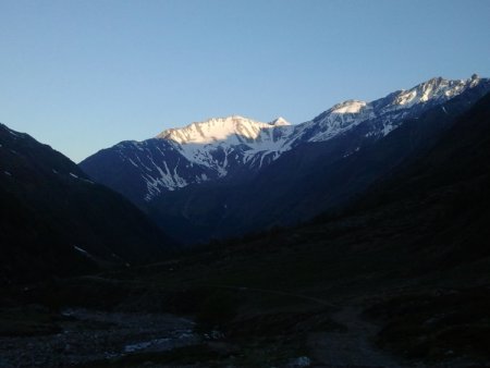
L'altissima, from Casera di Fuori, Val di Fosse

The Val di Fosse is a paradise for skialpers looking for long and rewarding hikes, both from the point of view of difficulties (never excessive), and for landscapes and variety of slopes.
In late spring / early summer many of the winter skialp trails are feasible on foot. You can thus discover how beautiful is this valley without snow. In addition to the high peaks that surround it (Similaun, Cime Nere, L'Altissima, Cima Bianca Grande, Cima Fiammante, Cima di Tessa) it offers a beautiful valley covered with pastures, a nice flat trail, several pastures and farms that offer food and beverage service.
Notes:
It is possible (even recommended) to ride by MTB the first part of the hike along the dirt road until you reach the valley floor and Fosse if there is no snow, in order to reduce the time of ascent and descent. Your knees will be grateful.
You shall properly evaluate the conditions of the ridge (which is quite long), that can be totally different on the the south-west and north-east sides. The route passes sometimes on one side and sometimes on the other.
Access
From Meran you drive along Vinschgau up to the village of Naturnser. Upon exiting the tunnel, which diverts traffic from the village, take the exit on the right and drive along the Schnalstal for about 10 km up to the junction for the Val di Fosse / Casera di Fuori, then you take taht direction and continue up to the end of the paved road.
You park near Casera di Fuori (food service).
Ascent
You walk along the valley bottom along a beautiful dirt road closed to traffic. In the first part you go through a beautiful forest, then through meadows and pastures you slowly gain altitude in the direction of the Passo Gelato (Eisjoch).
When the road gets steeper, shortly after the beautiful farm Eishof, you get to a fork, just before a bridge. The sign does not indicate the destination of the path that branches off to the left, but if you want to shorten a bit the way you can take this shortcut, while the trail reported on the map continues along the dirt road leading up to Fosse (huts and pond).
There you leave the path, you go around the southern foothills of the Altissima, and you reach the wide Pian del Catino. From there you can see the path that leads to the Gurgler Eisjoch, the gateway to the glacier.
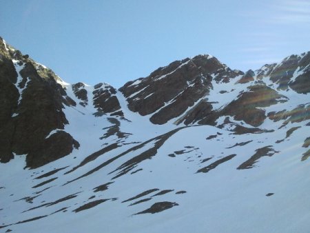
You go up through either one of the two grooves to the left, avoiding the right one, because of the frequent presence of large frames at the exit. In the background on the other side of the valley, the view opens on the tops of Texel.
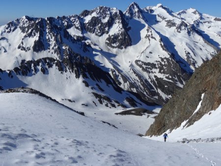
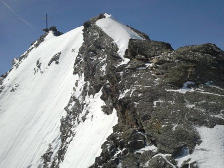
From the pass you can see now the rest of the path: a trail on the glacier, the northern summit, an exposed ridge, and the southern summit.
You rise along the outer edge of the glacier (proper equipment needed), until you get under the north ridge of the Nordgipfel (northern summit).
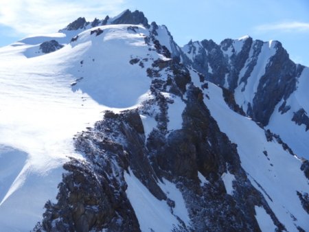
You climb a snowy gully and then with the help of a metal cable you reach the rocky ridge. You go up, still with the help of a cable, until you reach the northern summit.
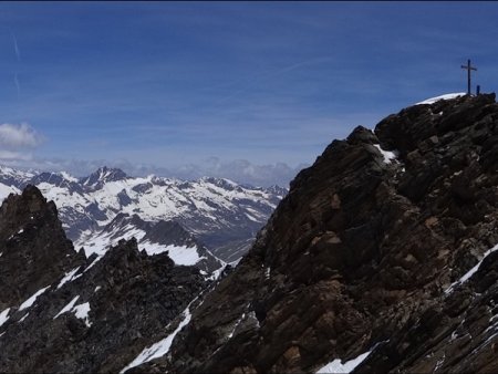
From there the view is wide and breathtaking. In addition to the peaks that surround the large hanging glacier to the north, you can see the cime Nere, the Similaun, the Wildspitze, the Palla Bianca, the Piz Bernina.
For skialpers this is the highest point; the ridge is normally very difficult to go through in winter, until late spring.
The tour continues along the rather exposed ridge. A cable allows you to follow it in safety, you just have to be cautious in case of snow, because in many places the cable could be submerged by the ice. Without using it, the difficulty is evaluated around the I / II degree, the travel time of about an hour or less, depending on conditions.
The southern summit offers a magnificent panorama to the other peaks of the range (Bianca Grande, Fiammante, Tessa), the Brenta, the Ortler, the Alps.
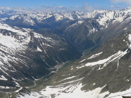
Beautiful also the view of the valley of Fosse: you can spot almost all of the long trail.
From there, the northern summit seems much smaller, but the difference is less than 20 meters.
Descent
For the descent you may decide to go back along the ascent route, or to go down to the Refuge Petrarca and Passo Gelato, to make a round trip. The trail reported on the map represents the latter.
The descent is difficult and dangerous because it takes place on broken rocks and small snowfields that often have an icy surface. You shall be cautious, because of the objective dangers (crumbling rocks, unstable stones), the fatigue accumulated in many hours of ascent, and the physiological drop of tension during the descent.
At the bottom of this downhill trail you reach the Refuge Petrarca (at the date of this report it was being rebuilt, because an avalanche destroyed it during the winter), and from there you you go down to rejoin the forward trail in the area of Fosse.
■ bd, 2014-06-21

