![]()

CIMA CAREGA
via the Vaio Bianco
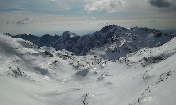
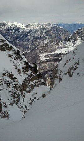
"Vaio" is the name used in southern Trentino, and in the Verona and Vicenza areas, to indicate a steep canyon, as those that run through many of the peaks in the area, particularly the Small Dolomites, a land of adventures and training of the strongest climbers in the area. Despite the relatively modest altitude (only a few peaks are just over 2200 meters) in winter these mountains have a look and offer difficulties very similar to those found in the high mountains.
The route described here addresses two of the easiest vaio of the area: the Vaio Bianco uphill and the Vaio dei Cavai downhill.
Depending on snow conditions, snowshoes may be useful in the lower part and in the descent, crampons and ice axes uphill. A helmet is recommended.
Note
This route shall be tackled only with optimal conditions in order to avoid taking risks: the vaio is very narrow and steep, a possible burst of snow or rocks is certainly conveyed along the way.
Access
From Rovereto take the Vallarsa, on the orographic left side and up to the end of the road, about two kilometers after the village of Ometto. After passing the few houses you can park your car in a clearing on the right just after the bridge and before a tunnel (closed to traffic).
Route
On foot, take the tunnel, coming out of it on a partially paved road (but forbidden to vehicles), flat, passing in the middle of a thick forest. Walk along the road for a few kilometers, passing (on the right ) the wide valley of Giare Bianche, that will be the path of return. Go past two water sources located right by the road and the deviation for the Vaio Pisavaca (signs with directions).
When you reach the entrance of the vaio, at an altitude of about 1300 m, at a bridge, you leave the road and start going up the valley covered with large boulders, until you get close to a rocky prominence. It is possible to overcome it by climbing the wall on the right (a step of II), and then by traversing in exposed position, or bypass it on the left going up a steep gully (which with little snow is quite crumbly), up to the Sella dei Cotorni. We opted for the second solution.
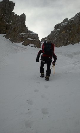
At the exit of the gully you find the path that leads to the vaio; you take it to the right, with some up and downs, then down to the bottom of the vaio. Wear your crampons if you didn't yet, wear a helmet and prepare the ax.
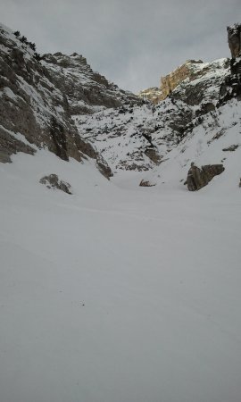
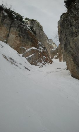
You go up along the bottom of the vaio, initially rather broad and gradually more and more narrow, passing between towering vertical cliffs. At the first fork, take to the right; here the slope increases up to about 40° and the space between the rocky ramparts decreases to about 5 meters.
Climb the main groove of the vaio for a few hundred meters until you come to a new fork, where you yake the left one, though narrower and less inviting.
After two semicurves left and right you reach the foot of a huge stuck boulder. Depending on snow conditions, the rock may be more or less covered with snow, and therefore may be more or less easy to overcome.
If you are unable to face it directly, you can climb up the right wall, then move to the bottom of the vaio once past the boulder:

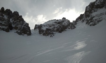
At this point the vaio opens, the slope is high (45-50°), you are near the exit: take the groove on the left, climb it up to the top where, unfortunately, unlike many other outlets where the vaio steeps up, the slope decreases.
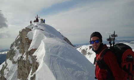
You are now leaving the vaio, but the climb is not over yet. You have to climb up the last slopes of the Cima Carega, on the right as you go up. You can go up a little to the left of the edge of the ridge, or take the military route, if it is not buried by snow. Just below the summit you have to cut across the ridge (facing south) to move near the Refuge Fraccaroli, from where you can climb to the top.
Attention in case of wind-drifted snow: often with a north wind the conditions of the vaio are optimal, but the snow accumulates on this side making it extremely unstable and dangerous. Depending on the possible conditions it may be possible / advisable to cross the ridge (staying close to the rocks of the summit) up to a steep gully (about 60°). Rather than going to the shelter it is possible to go up the gully, to reach the ridge, from which in a few steps you get to the summit (the map shows this option).
Return
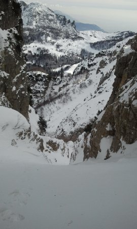
The return path runs on the north side of the Cima Carega. From the top you can climb down into the valley below and follow the arched path that leads near the output of vaio Pisavacca (SAT sign). After this vaio (also feasible, but with extreme caution if it hasn't yet unloaded its snow) you go to the entrance of the Vaio dei Cavai. Although it is possible to descend by several entrances, it is advisable to take the first one (about 40°).
This way you get to the Busa della Neve, and from there you continue the descent, still steep, on the bottom of the valley, rather large, but that narrows in the final part. You get out that way in the wide valley of Giare Bianche, that you had encountered on the path forward, and you rejoin the road, going left, and then back to the car.
■ bd, 2013-02-09


